... Because radiation happens!
Mission Overview
|
The Polar Operational Environmental Satellite (POES) Program is a cooperative effort between NASA and the National Oceanic and Atmospheric Administration (NOAA), the United Kingdom (UK), and France.
The Goddard Space Flight Center (GSFC) is responsible for the construction, integration and launch of NOAA satellites. Operational control of the spacecraft is turned over to NOAA after it is checked out on orbit, normally 21 days after launch. The NOAA satellites carry seven scientific instruments and two for Search and Rescue.
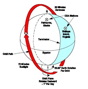
Currently, the POES mission is composed of two polar orbiting satellites known as the Advanced Television Infrared Observation Satellites (TIROS) - N (ATN). Operating as a pair, these satellites primarily provide data used for long-range weather forecasting ensuring that infrared and non-visible data for any region of the Earth are no more than six hours old.
|
|
| |
|
POES data provides economic, humanistic, and environmental benefits on a continuous, reliable basis. The benefits that directly enhance the quality of human life and protection of Earth's environment include:
- Over 50% of the U.S. public utilizes 3-to-5 day weather forecasts for planning recreational and business activities
- City, state and federal government agencies utilize TIROS data products to manage resources, plan civic and industrial expansion, schedule services, and monitor population growth
- Countless lives and properties have been saved by monitoring severe storm movement and forecasting national disasters
- From monitoring ozone levels and animal migrations patterns to forecasting and detecting forest fires, TIROS is a vital tool of environmental research and protection
- Global data collected about the earth is used to monitor the environment and trend changes over time
- Search and Rescue instruments carried on POES satellites contributed to saving over 24,500 lives
|
NOAA-N and -N', are the latest in the series of advanced TIROS-N (ATN) satellites.
+ Read more
If you find broken links or incorrect information, please contact us at webmaster@radiation-effects.com
NOAA-N', the last in the series of TIROS ATN, was successfully launched on February 6, 2009 from Vandenberg AFB, CA, by a Delta II launch vehicle.
The spacecraft will continue to provide a polar-orbiting platform to support (1) environmental monitoring instruments for imaging and measuring the Earth's atmosphere, its surface, and cloud cover, including Earth radiation, atmospheric ozone, aerosol distribution, sea surface temperature, and vertical temperature and water profiles in the troposphere and stratosphere; (2) measurement of proton and electron flux at orbit altitude; (3) data collection from remote platforms; and (4) the Search and Rescue Satellite-Aided Tracking (SARSAT) system.
Additionally, NOAA-N' is the fifth in the series of support dedicated microwave instruments for the generation of temperature, moisture, surface, and hydrological products in cloudy regions where visible and infrared (IR) instruments have decreased capability.
This spacecraft carries an Advanced - DCS.
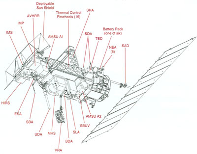
The NOAA-KLM instruments include: the Advanced Very High Resolution Radiometer (AVHRR), the High Resolution Infrared Radiation Sounder/3 (HIRS/3), the Advanced Microwave Sounding Unit (AMSU-A1 and -A2), the Advanced Microwave Sounding Unit (AMSU-B), the Data Collection System (DCS), the Search and Rescue Repeater (SARR), the Search and Rescue Processor (SARP), and the Space Environment Monitor (SEM).
The NOAA-NN' instruments include: the Advanced Very High Resolution Radiometer (AVHRR), the High Resolution Infrared Radiation Sounder/4 (HIRS/4), the Advanced Microwave Sounding Units (AMSU-A1 and -A2), the Microwave Humidity Sounder (MHS), and the Solar Backscatter Ultraviolet Radiometer (SBUV/2), the Data Collection System (DCS), the Search and Rescue Repeater (SARR), the Search and Rescue Processor (SARP), and the Space Environment Monitor (SEM).
POES >300 keV Electrons, 90 Deg
POES 35-70 MeV Protons, Omni
POES 70-235 MeV Protons, Omni
POES 140-275 MeV Protons, Omni
POES Northern Auroral Map
POES Southern Auroral Map